Pokhara second city, at least in tourist terms, Pokhara is the end point for the famous Annapurna Circuit trek and the starting point for a dozen more treks through the mountains of the Annapurna Range, including the perennially popular Jomsom Trek and the equally dramatic (but less busy) trek to the Annapurna Sanctuary. It's unashamedly touristy, in the Thamel mould, but the setting is spectacular - the perfect pyramid of Mt Machhapuchhare looms high above Pokhara, reflected in the placid waters of Phewa Tal.
For many travellers, Pokhara represents a last chance to stock up on creature comforts before hitting the mountain trails. For others, it's a place to enjoy a steak dinner and cold beer after weeks of daal bhaat in the hills. Even if you aren't a dedicated trekker, there's plenty here to keep you busy. Pokhara has numerous museums and there are some fascinating caves, waterfalls and Tibetan villages in the surrounding hills.
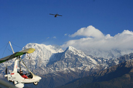
For the adventurous, travel agents in Pokhara offer a slew of adventure activities, from trekking and microlight flights to river rafting and jungle safaris. Paragliding from Sarangkot viewpoint has to be one of the most thrilling experiences in the subcontinent. Alternatively, bring a good book and spend your days reading in a café overlooking languorous Phewa Tal. Phewa is the 2nd biggest lake of Nepal after the remote Rara Tal. Pokhara also offer the Ultralight flight, Mountain flight over the Annapurnas, Zipflyer, Boating, Rafting etc.
Pokhara is situated in the northwestern corner of the Pokhara Valley, which is a widening of the Seti Gandaki valley that lies in the midland region (Pahad) of the Himalayas. In this region the mountains rise very quickly and within 30 km, the elevation rises from 1,000 m to over 7,500 m. As a result of this sharp rise in altitude the area of Pokhara has one of the highest precipitation rates in the country (3,350 mm/year or 131 inches/year in the valley to 5600 mm/year or 222 inches/year in Lumle). Even within the city there is a noticeable difference in rainfall between the south and the north of the city, the northern part of the city situated at the foothills of the mountains experiences proportionally higher amount of precipitation. The Seti Gandaki is the main river flowing through the city. The Seti Gandaki (White River) and its tributaries have created several gorges and canyons in and around the whole city which gives intriguingly long sections of terrace features to the city and surrounding areas. These long sections of terraces are interrupted by gorges which are hundreds of meters deep. The Seti gorge runs through the whole city from north to south and then west to east and at places these gorges are only a few metres wide. In the north and south, the canyons are wider.
In the south the city borders on Phewa Tal (4.4 km2) at an elevation of about 827 m above sea level, and Lumle at 1,740 m in the north of the city touches the base of the Annapurna mountain range. 3 eight-thousand meter tall peaks (Dhaulagiri, Annapurna, Manaslu) can be seen from the city. The Machhapuchhre (Fishtail) with an elevation of 6,993 m is the closest to the city. The porous underground of the Pokhara valley favours the formation of caves and several caves can be found within the city limits. In the south of the city, a tributary of the Seti flowing out of the Phewa Lake disappears at Patale Chhango (पाताले छाँगो, Nepali for Hell's Falls, also called Davis Falls, after someone who supposedly fell into the falls) into an underground gorge, to reappear 500 metres further south. To the south-east of Pokhara city is the municipality of Lekhnath, a recently established town in the Pokhara valley, home to Begnas Lake.